Natural Flood Management
Introduction
The Calder Valley is renowned for its flooding. There is a lot of water, the valleys are steep sided and carved by water.
But water obviously doesn’t start its journey at the bottom of the valley, but on the moors, right at the top of the fells. It is the responsibility of landowners from the very top, down the valley sides to help to keep water where it should be (in the bogs), and to try to slow the flow down towards the valley bottom.
This design looks at selecting which methods would work for our land and their implementation and maintenance
Ethics
Earth Care – Use sustainable materials, sourced on site, working with sensitive habitats, minimal disruption.
People Care – Using local organisations, keeping money in local economy
Future Care – Opening as a demonstration site, involving students, sharing case study, Regenerative and sustainable practices
Principles used to guide design
Mollison
Design Framework – GoSADIM
Goal, Survey, Analysis, Decision, Implementation, Maintenance
Client
Myself – a personal project
Dates
November 2022 – November 2024
Tools Used
Observation over time, Video evidence,
Resources Used
- Benjamin Fenton – Calderdale Council, Flood Risk Management Team
- The Permaculture Earthworks Handbook – Douglas Barnes
- https://www.gov.uk/countryside-stewardship-grants/rp32-small-leaky-woody-dams
- https://www.moorsforthefuture.org.uk/our-resources/file-preview?id=80745
- https://www.gov.uk/countryside-stewardship-grants/earth-banks-and-soil-bunds-rp9
- https://www.sepa.org.uk/media/219450/bank_protection_guidance.pdf
- https://www.therrc.co.uk/MOT/Final_Versions_%28Secure%29/4.1_Skerne.pdf
- https://www.ydrt.org.uk/wp-content/uploads/2021/04/NFM-Leaky-Dams-guide.pdf
Link to ALP & my personal objectives
This design is relevant and achievable. This design blends using design methodologies and tools to a practical project, and builds links with a local enterprise.
Goal
To create a plan to manage the flow of flood water using materials found onsite and without damaging fragile eco-systems and creating opportunities for creating different habitats.
Survey
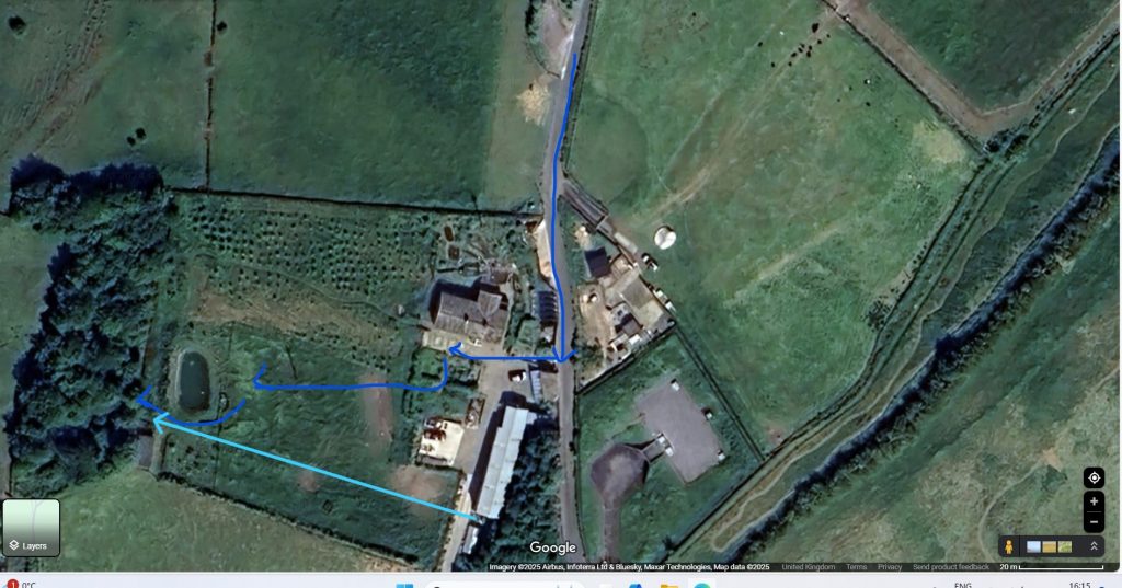
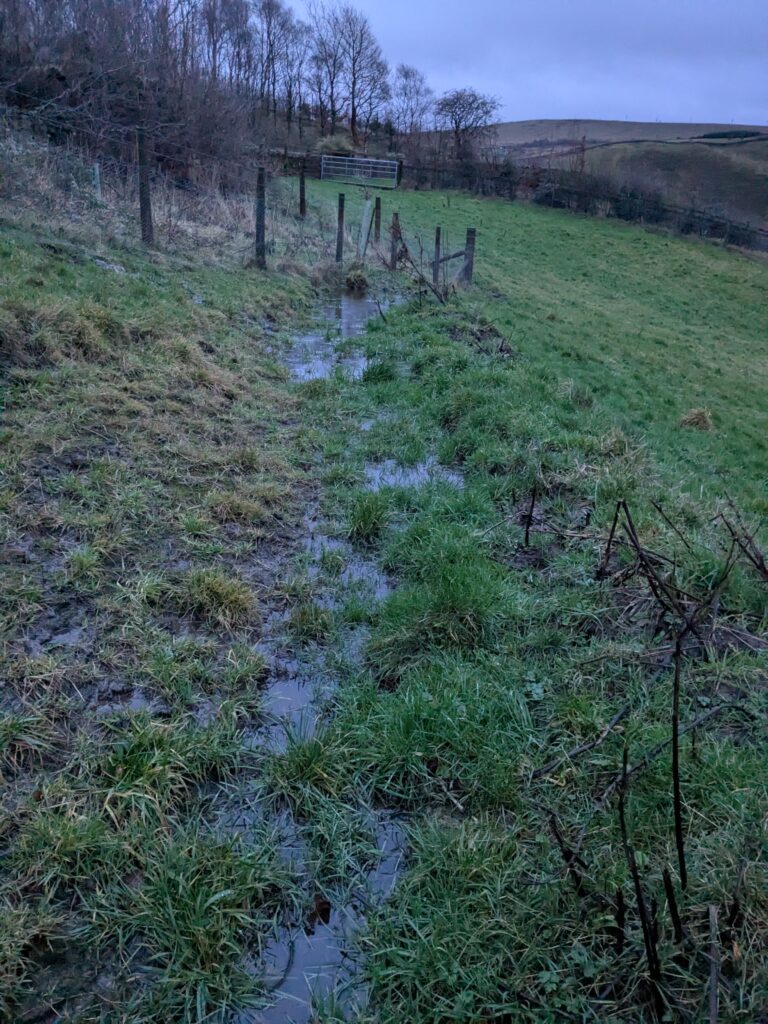
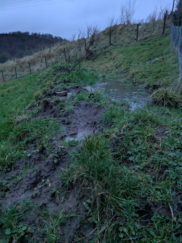
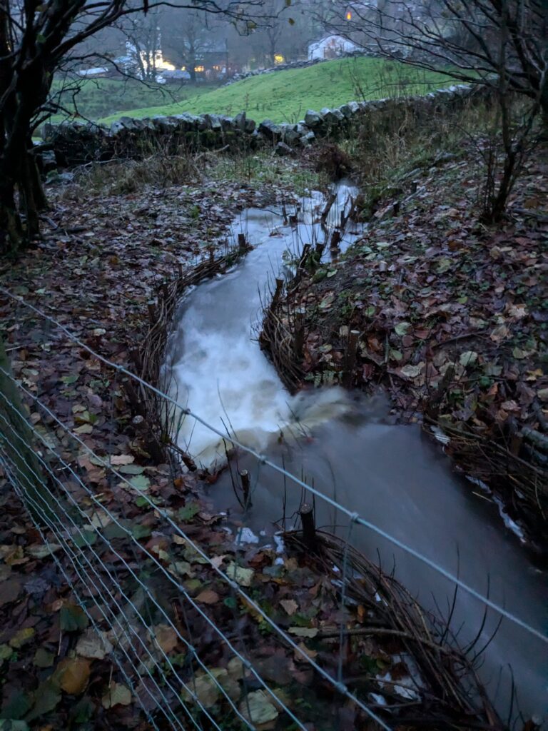
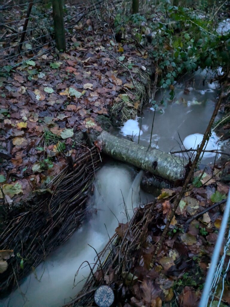
The below videos shows a flood event (apologies for the dodgy videography). The water comes from springs and overflowing field drains on land above ours. It happens only once or twice a year, but the amount of water threatens to overload the large pond. This isn’t the worst it has been, but gives a good indication of the ‘average’ flood event.
There is a drain that flows under the field, and comes out into the open at the bottom of the slope.
It runs as a stream through the woods at the bottom before exiting into a drain under the neighbours field. The force of the water has caused deep erosion.
Over a few years I have observed the flow, and we have put in small scale emergency interventions and landscaping to stop it deluging the pond and direct it away from the house. The map below shows the direction of the flood run off water (Dark bliue lines), but also show the water that flows through a drain on our land.
Habitats that need protecting
My fields are home to rare, red list, grassland fungi. My priority is to protect these delicate habitats. As well as fungi, the fields are rich in wild flowers and other grassland plants.
Resources on site (or almost)
I have a woodland that needs trees thinning. Many of the trees were planted very closely together, and are quite spindly, there is a mix of Hazel, Oak, Goat Willow Alder, Holly, Rowan and Birch. There are also 2 large Ash trees which have begun to show signs of Ash die back. Over the past 6 years I have been growing and coppicing Osier willows.
I have a neighbour with a mini-digger.
Analysis
I looked at different options open to me to slow the flow of water, and then used a decision matrix to compare how each of them fitted into my needs.
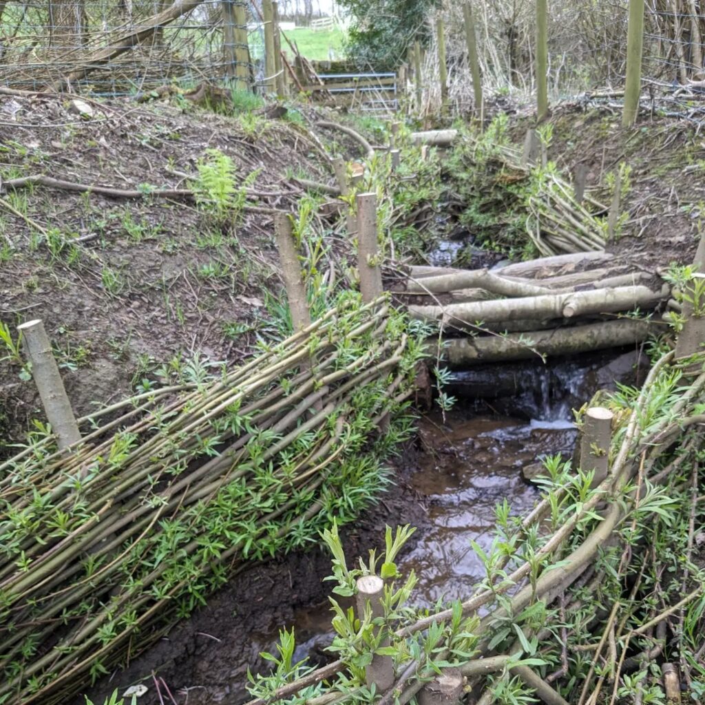
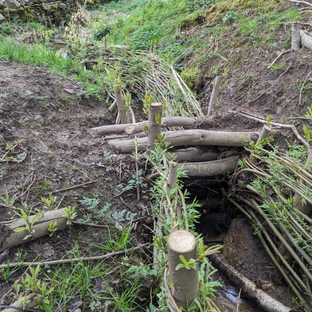
Leaky Dams: Resource used, https://www.gov.uk/countryside-stewardship-grants/rp32-small-leaky-woody-dams and https://www.moorsforthefuture.org.uk/our-resources/file-preview?id=80745, https://www.ydrt.org.uk/wp-content/uploads/2021/04/NFM-Leaky-Dams-guide.pdf
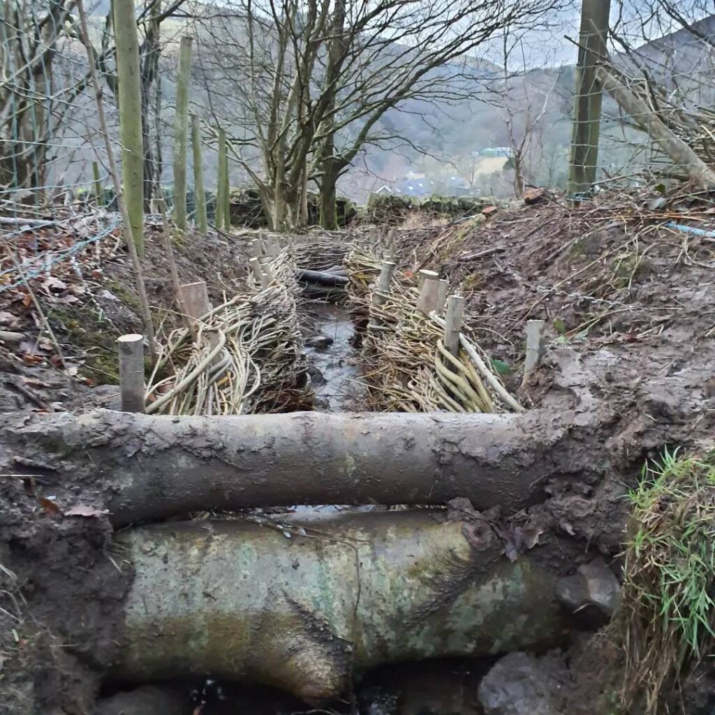
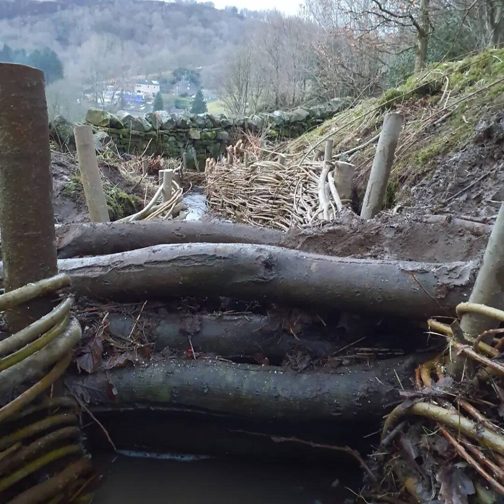
Create slightly permeable blocks use logs or timber planks across a stream or gulley for the purpose of slowing the flow of water down stream. They can create pools and also trap sediment which could allow revegetation.
Advantages: No need to bring in materials or use heavy machinery. Can use wood on site.
Disadvantages: need experience to build correctly, using logs rather than planks can allow water to permeate in unexpected ways, however, if the main structure is there, additional material can be added upstream.
Yields: Sediment trap, pools, holding water higher in landscape.
External help needed: Construction experience, tree surgery, muscles to move logs.
Scrape & Berm: Resource used: The Permaculture Earthworks Handbook – Douglas Barnes and https://www.gov.uk/countryside-stewardship-grants/earth-banks-and-soil-bunds-rp9#designing-and-constructing-the-earth-bank-or-soil-bund
By locating the usual path of flood water, identify an appropriate place to interrupt the flow. Find the contour across the flow, which allows sufficient space above to scrape soil into a high enough berm. The job is (in theory) small enough to allow for manual excavation, however, using a small digger, means that the job will be done more quickly.
Advantages: I have the knowledge to find the contour. We have a neighbour with a mini-digger, which isn’t heavy enough to damage the grassland (if land is dry). As the berm is quite small, an engineer is not needed.
Disadvantages: There will be an area of bare soil until seeds grow. Neighbours cows will need to be kept out of the area whilst the berm re-vegetates.
Yields: Pools, holding water higher in landscape. Deeper area of soil (bund)
External help needed: Digger driver or lots of hard working, strong people
Attenuation Pond: Resource used: https://www.susdrain.org/delivering-suds/using-suds/suds-components/retention_and_detention/retention_ponds.html and https://slowtheflow.net/flood-prevention-at-oldroyd/#more-5477 plus conversation with council natural flood management expert.
An attenuation pond captures storm water and holds it either for use in drier months or until it soaks naturally back into the landscape. The control of flow rates from spill over from the pond needs to be controlled and carefully calculated. Building on a slope requires engineering knowledge.
Advantages: hold a large body of water, high ecological benefits (create ponds/wetland area)
Disadvantage: As we are a steeply sloping site, it would require a great knowledge of engineering to create the pond, and excavations would have a massive impact on the grassland.
Yields: Sediment and water capture. New wetland ecosystem. Water held higher in the landscape.
External help needed: engineer, experienced construction team.
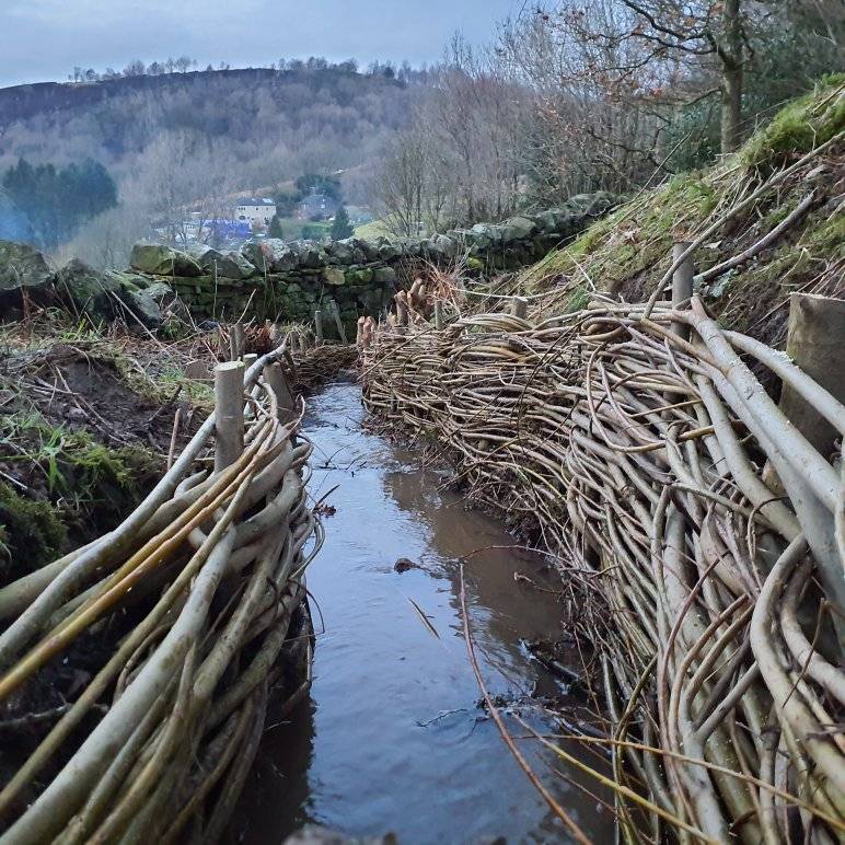
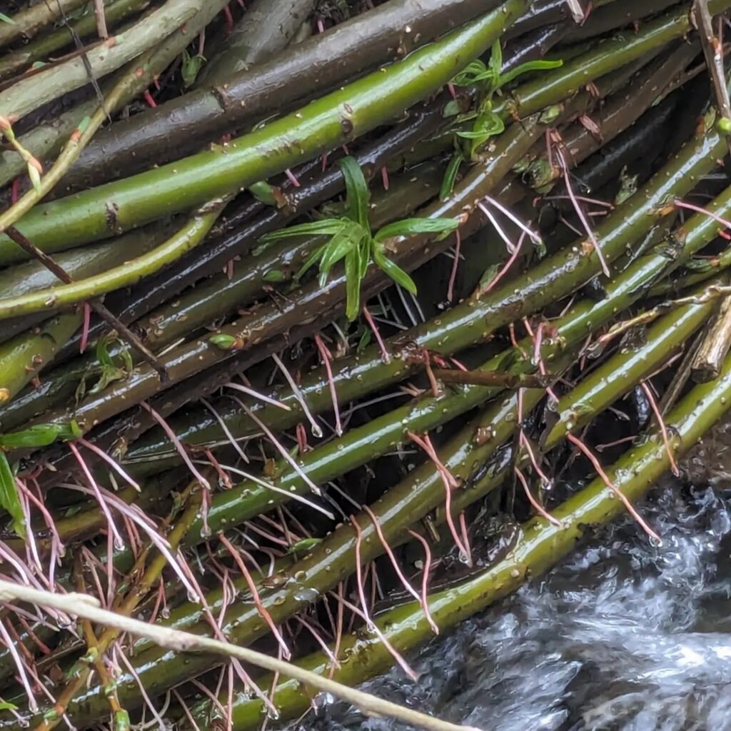
Willow spiling revetments: Resources used: https://www.therrc.co.uk/assets/archive/MOT/Final_Versions_(Secure)/4.1_Skerne.pdf and https://www.sepa.org.uk/media/219450/bank_protection_guidance.pdf
Revetments using willow spiling uses thick willow poles driven into the ground, with thinner willow withies woven around these poles. The poles and woven willow withies support steep, deep banks from erosion.
Advantages: Uses resources I already have on site. Simple installation
Disadvantage: Will need experience and a team of people to gather materials and install. Willow needs to be cut and installed within a short time frame to maximise re-growth.
Yields: Erosion protection, more willow, deer food, habitats
External help needed: installation experience, people to help harvest materials
Fascines: Resources used: https://leedscoppiceworkers.co.uk/fascine-installation/
Fascines are long bundles of brushwood that are tied together with natural twine that can be staked to the ground to create barriers and defences to combat land erosion caused by rainfall and flooding. They capture sediment and organic matter and eventually become embedded in the bank or slope.
Advantages: Easy to install, light to manoeuvre.
Disadvantage: Time consuming to create, would need a lot of brushwood that I don’t have. The force of the water could dislodge the brush, wouldn’t hold water back on the slope sufficiently.
Yields: Traps sediment so creates, wildlife habitat
External help needed: none
| Minimal impact on land | Uses on site resources | Easy to maintain | Provides extra habitats for wildlife | |
|---|---|---|---|---|
| Leaky Dams | X | X | X | X |
| Simple Scrape & Berm | X | X | X | X |
| Attenuation Ponds | X | X | X | |
| Willow Spiling | X | X | X | X |
| Fascines | X | X | X |
What help is out there?
From the analysis, it became clear that this wasn’t a project I could tackle by myself. I needed external help and the funds to pay for it!
Financial – Luckily, as we are an area prone to flooding, Calderdale Council have a Natural Flood Management (NFM) Grant Fund. The fund enables landowners to undertake land and water management techniques to help build resilience during heavy rainfall events. I am eligible to apply for this funding.
Expertise – There are a number of local organisations who I could partner with. Conveniently the grant application handbook, included their contact details and areas of specialism. I selected a wonderful organisation called Forus Tree a “worker’s co-operative, a not-for-profit social enterprise with a focus on managing the environment in the Calder Valley and beyond”. They have experience of installing willow revetments and leaky dams, and also have an ethos that aligns with mine.
I can use our neighbour and his digger for the earthworks.
Restrictions:
Decision
Based on the decision matrix, Leaky dams, willow revetments and a simple berm meet all my criteria. I have the resources to hand, they have minimal impact on the grassland and should also provide extra areas of habitat for wildlife.
Check against Principles – Mollison (and ethics)
Work with nature rather than against it – Willow loves to grow near water, using cuttings of goat willow for stakes, and osier willow to weave, installing willow spiling should create a living revetment to help prevent or at least slow down bank erosion. The flood water always takes the same course down the field, so easy to work out where to interrupt it’s flow.
The problem is the solution – My ash trees show signs of ash die back. Cutting them right back provides us with logs for the leaky dams (and minimal effort to move them), brash to protect the stools and firewood for the house. I have an excess of willow, so makes sense to use it!
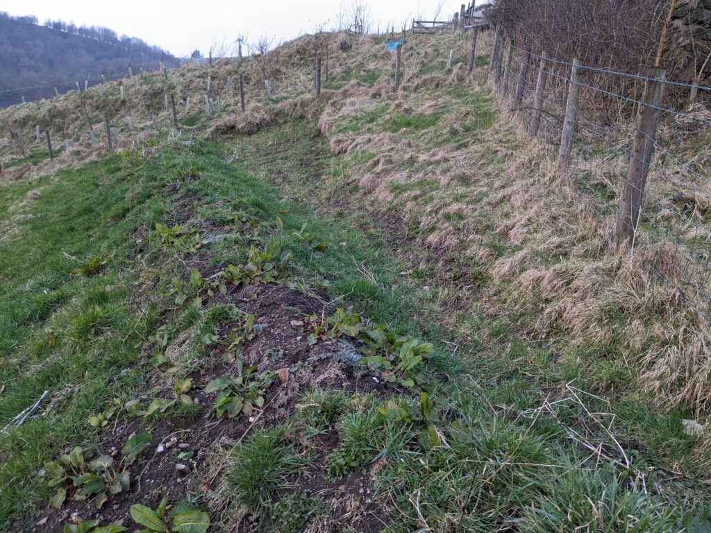
Make the least change for the greatest possible effect – Water goes where it wants to go. By observing the flow of water, I gained a better understanding of where I needed to intervene. Putting the berm on a contour at the top of the slope means that the fungi rich grassland is unharmed and minimal effort needed to hold back the flood waters. The berm only needs to be approx. 30cm high on the inner wall. The bare soil will be sown with appropriate local grasses, clovers and wild flowers.
The yield of the system is theoretically unlimited – New willow will create more willow to use for crafts, for deer to eat, as habitat for invertebrates and small birds and mammals. The re-seeded berm and scraped ground will produce more grasses and plants will self seed and regenerate the soil. The cut ash trees will sprout from their stools. The banks of the stream won’t erode, ensuring the soil stays where it’s supposed to be, supporting trees.
Everything gardens – The willow revetments should sprout and grow. The leaky dams will create deeper pools. The berm will create temporary ponds.
Earth Care – I will use materials, sourced on site, creating new habitats and preventing the erosion of soil. The project will slow the flow of water towards the valley.
People Care – By using Forus and a neighbour, I am supporting local people, organisations and jobs.
Future Care – My project is a case study on the Calderdale NFM website, and has also been publicised by Forus. We have an agreement that visitors are welcome to come and see us to learn what we did & why.
Stacking Functions.
This project feels like the most closed loop project I’ve done.
Felling trees creates material for the leaky dams, as well as fuel and brushwood to protect the sprouting stumps whilst providing habitat piles.
Leaky dams slow the flow whilst using on-site materials, create habitats, as well as bridges across the stream (no more leaping!)
Revetments use willow I have been growing for windbreak over the past few years, a regenerative material. They will help stop erosion, and also create further habitats (and even more willow). I share willow with friends and neighbours for planting and crafting.
The berm will create a chance to sow wildflowers and more native grasses, promoting biodiversity whilst also creating a potential area to plant in the field, without disturbing the valuable grassland. It will also stop erosion of the soil and capture water in flood events.
All while supporting local organisations and people.
Implementation
I identified a need for this project after boxing day floods in 2015. I took small steps, planting willow and we altered some solid structures diverting water away from the house and into the field.
I missed the timescales to apply in 2021, but sought advice from the Natural Flood Management team, and had a site visit from Forus where we discussed how many leaky dams to install and where the spiling would be best placed. We agreed three leaky dams and approx. 20m of spiling.
In November 2022 I applied for and was awarded a grant to pay for the construction of the earth bund, the leaky dams, willow spiling, and tree surgery. Maintenance was also included in this grant.
Timescale restrictions – Implementation for the spiling and dams was reliant on trees being dormant, and willow about to burst forth, so late winter (Jan/Feb) 2024 was put on the work schedule.
The berm needed to wait for dry soil, but with enough time for seeds to take. We booked the digger for Spring 2023.
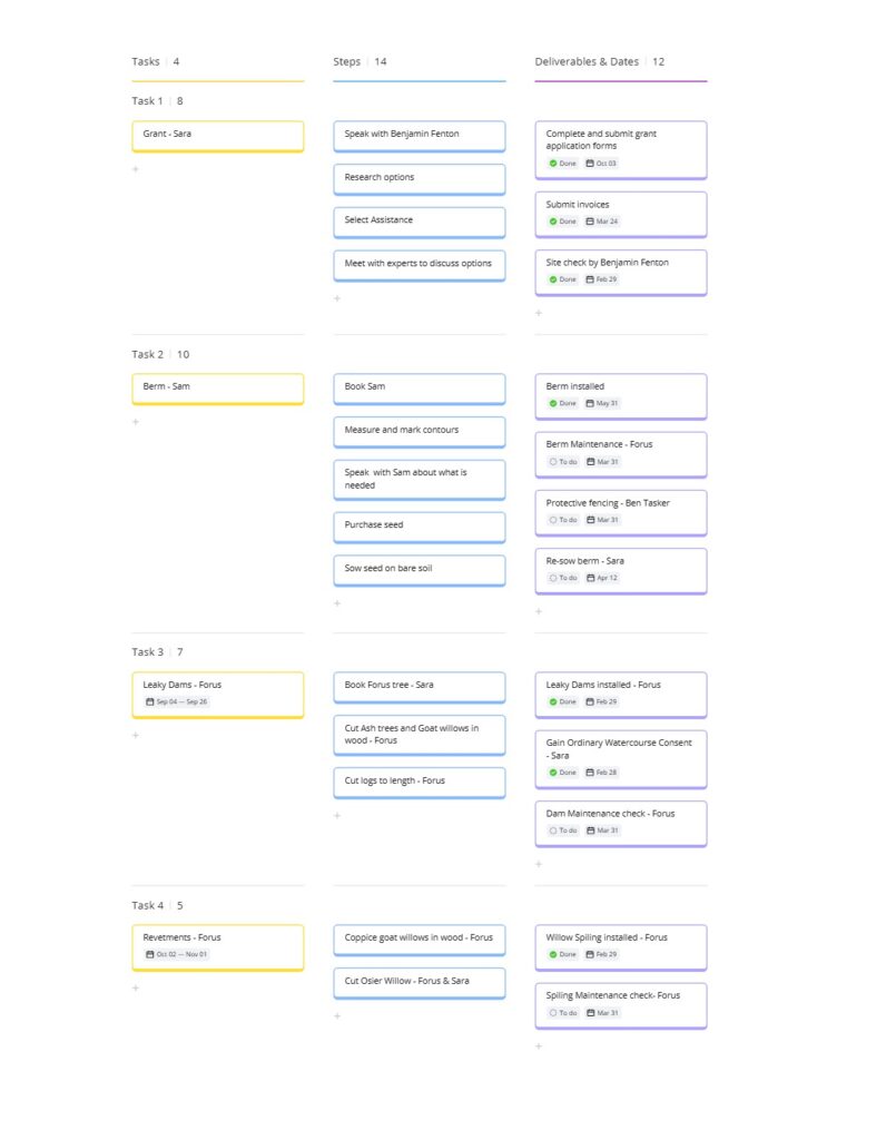
A small team from Forus installed the willow spiling and berms to our agreed specifications in January 2024. See below for installation pictures (and then follow on photos from Spring 2024, with willow doing its thing)


Total implementation time (including tree surgery was about 5 days.
Maintenance
The grant included funds to help with maintenance, though planned maintenance is minimal, after observing how the interventions worked, some changes are needed. These will be carried out late winter/early spring 2025.
Berm – I kept cows out of field for the first year to help berm settle and seeds to grow. However, they proved too heavy once allowed in, and trashed part of the berm. This meant that the water was not held back as much as it should have been. The autumn floods also highlighted areas that need a bit more levelling out to better follow the contour behind the berm.
This will be restored by hand and re-sown in Spring of 2025. We will also invest in a line of stock-proof fencing to keep cows off it in future.
Dams & Revetments – held up well with the floods. We’ll check this winter for any damage or gaps and keep an eye on whether silt needs to be dug out. Willow can be trimmed back (if not eater by the deer).
Reflection
What went well – the whole process went really smoothly, and within the timescales we set. The Forus team, did an amazing job with their installations.
What needs to change – the berm needs a bit of reconstructing. In hindsight, I should have known that the cows would cause damage, and I should have put up some fencing to start.
Did this design framework work? – GoSadim was a great framework for this design. It is straightforward, and ensured I looked beyond the initial installation.
How did the principles shape the design – by using these Mollison principles, I ensured that the project was as ‘closed loop’ and simple as possible. All materials were resourced on site and people involved are all part of our local community. The principles chosen bound this project to the three ethics of Earth care (new or improved eco-systems were at the heart of the project, People care (the grant helps a small local co-operative keep going), Future care – the project not only helps stop further erosion, but we are also able to share our experience and lessons learned with other landowners.
Will this design be useable by others? – I hope so, I thing it is clear and not too wordy. Where possible I have included links to resources that can be used by others.